Conduct comprehensive assessment of underground safety in KL
The step was appropriate considering that natural disasters were not the biggest threat in a developing city, but rather human actions.

SHAH ALAM - It is time for the authorities, with the assistance of various experts, to study the underground risks and the interaction with utility or infrastructure systems, particularly in Kuala Lumpur, to reduce the risk of disasters and loss of life.
Universiti Malaya Science Faculty's Department of Geology's senior lecturer Dr Elanni Md Affandi said that the step was appropriate considering that natural disasters were not the biggest threat in a developing city, but rather human actions.
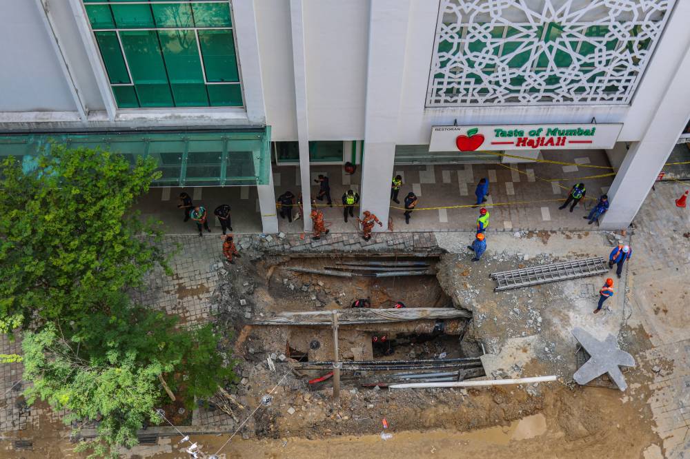
The occurrence of an eight-metre-deep sinkhole on Jalan Masjid India calls for a comprehensive study involving all parties with the help of geophysical tools could provide a clear picture of the underground conditions in Kuala Lumpur.
"Looking at the geological facts and recent reports, we are aware that the sewerage pipes have ruptured, causing fast-moving water to carry fill material, resulting in the pedestrian structure losing its support.
"However, this is just what we see at the surface. Questions still arise regarding the conditions at depths of 10 to 20 metres, or possibly the soil thickness reaching 30 metres below.
"This would prove that the area is underlain by geology different from what was previously mapped. Is this incident referred to as slip, a sinkhole or merely soil settlement triggered by the failure of the utility system design?
"Previous incidents of soil slip in the same location indicate that the area is at high risk, but what follow-up actions have been taken by the authorities or have they just repaired the surface that we see?" she questioned in a written commentary posted on the Department of Geology UM's Facebook page.

She added that the sinkhole incident area at Masjid India was not located in a limestone area as some have claimed; rather, the location was underlain by phyllite, quartzite and sandstone of the Kenny Hill Formation, adjacent to limestone.
"In recent years, many sinkhole incidents have occurred in Kuala Lumpur, but the triggers have been more related to ruptured pipes, changes in groundwater levels and construction activities.
"The likelihood of sinkholes occurring in areas other than karst, such as in the Kenny Hill Formation, is low because it requires two factors to coexist: a thin layer of weathered soil and cavities from underlying limestone," she said.
She also addressed speculation that Kuala Lumpur would sink or 'fall' into a large cave beneath it.
"Historically, Kuala Lumpur was part of the Klang Valley, which has been a tin mining area since the 1850s. Due to the city's very low elevation, it is known as a floodplain, so it is not surprising that floods frequently occur in the capital.
"However, the increased frequency and intensity of rainfall due to climate change has further accelerated processes contributing to geological disasters such as landslides, sinkholes and soil settlement," she said.


